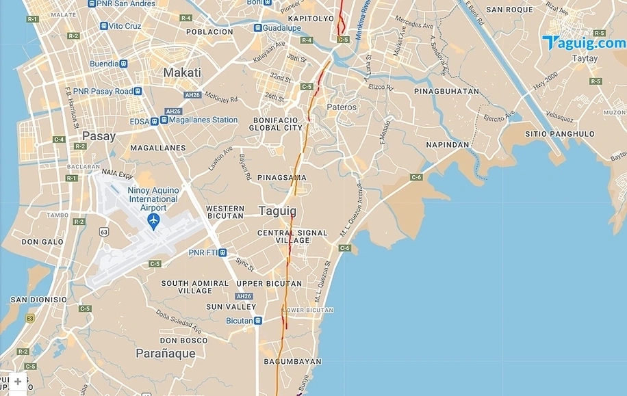
A section of C-5 Road traversing Taguig City is among the areas vulnerable and may collapse should a powerful earthquake occur, due to a phenomenon known as liquefaction.
This area on C-5 forms part of Barangay Fort Bonifacio, one of the barangays in Taguig that is crossed by the Marikina West Valley fault line.
According to the Philippine Institute of Volcanology and Seismology (Phivolcs), liquefaction is a process wherein saturated sediment behaves like liquid when there is an increase in pore pressure and a decrease in effective stress between solid particles, usually caused by the presence of liquid. This happens when there are excessive tremors, especially during powerful earthquakes.
It has been discovered that the barangays of Signal and Pinagsama are also threatened by liquefaction as they are situated on "clay-loam" soil and close to Laguna de Bay.
Aside from Taguig, coastal areas in Marikina, Pasig, Caloocan, Malabon, Navotas, Muntinlupa, Pasay, Las Piñas, and Pateros are also at risk of liquefaction.
In order to be better prepared for any disaster, Taguig's city government actively participated in the Nationwide Simultaneous Earthquake Drill (NSED) on September 7, 2023.
The NSED was conducted in various locations throughout Taguig, including schools, health centers, offices, and residential buildings in the city.
Participants were taught the basic principles of action during an earthquake, which is the "duck, cover, and hold" technique, and how to reach safe spots.
The Taguig City Disaster Risk Reduction and Management Office (CDRRMO) also conducted a mock rescue operation where city government personnel rappelled down buildings, simulating the rescue of people trapped due to an earthquake.
A first-aid simulation was also conducted to demonstrate Taguig's preparedness should a real emergency occur.
(Screenshot of Marikina West Valley Fault Line from Google Maps)
(Photos by Taguig PIO)


